20260602 CDTL Căn cứ tầu cộng tại Fiery Cross Reef
***
Với những tọa độ có sẳn độc giả chỉ copy và paste vào Search trên Google.com sẽ thấy được hình ảnh.
***
20241110 CDTL Tuyên Cáo Lãnh Thổ Lãnh Hải VN
https://bachvietnhan.blogspot.com/2024/11/20241110-cdtl-tuyen-cao-lanh-tho-lanh.html
20241214 CDTL South Vietnam Not Bound by Geneva Accords 1954
https://bachvietnhan.blogspot.com/2024/12/20241214-cdtl-south-vietnam-not-bound.html
20190910 Petition of the citizens of the Republic of Vietnam
https://bachvietnhan.blogspot.com/2019/09/20190910-petition-of-citizens-of.html
20250130 Cộng Sản Giặc Hồ Đầu Hàng Hoa Kỳ Năm 1973
https://bachvietnhan.blogspot.com/2024/12/20241231-ap-ba-chuc-dau-moi-mot-tham-hoa.html
http://www.youtube.com/watch?v=hwvXyzo7MjM
20120414 Hải Chiến Hoàng Sa
https://bachvietnhan.blogspot.com/2012/04/20120414-hai-chien-hoang-sa.html
Điều chưa kể sau cuộc hải chiến Hoàng Sa 1974
https://saigonnhonews.com/thoi-su/thay-gi-tren-mang/dieu-chua-ke-sau-cuoc-hai-chien-hoang-sa-1974/
Căn cứ tầu cộng tại Fiery Cross Reef
9°33'0.00"N 112°53'25.00"E
https://apps.dtic.mil/sti/trecms/pdf/AD1128253.pdf
https://storymaps.arcgis.com/stories/476d0c84a9f84046b9866db8f9405f72
https://amti.csis.org/fiery-cross-reef/
https://storymaps.arcgis.com/stories/476d0c84a9f84046b9866db8f9405f72
https://apps.dtic.mil/sti/trecms/pdf/AD1128258.pdf
https://www.marineregions.org/downloads.php
Visual Observation Post/Gun Mount
9°33'25.55"N 112°54'19.05"E
9°33'21.54"N 112°54'17.15"E
9°33'0.30"N 112°53'51.45"E
9°32'50.68"N 112°52'53.95"E
9°32'30.07"N 112°53'12.33"E
1-Over-the-Horizon Radar North
9°33'40.72"N 112°54'0.66"E
2-HF Monopole Array Signals Intelligence
9°33'35.42"N 112°54'3.44"E
3-Troposcatter Station North to Subi Reef
9°33'33.49"N 112°54'7.58"E
4-Satellite Communications SATCOM Earth Station
9°33'31.25"N 112°54'6.05"E
9°33'1.75"N 112°53'30.27"E
5-Electronic Intelligence Array North
9°33'25.44"N 112°54'20.34"E
6-Surface-to-Surface Missile Facility
9°33'23.83"N 112°54'18.23"E
7-Air Surface Radar 3 Tower
9°33'18.56"N 112°54'12.51"E
8-HF Antenna Array
9°33'33.34"N 112°54'0.55"E
9-Air Surface Radar
9°33'33.73"N 112°53'56.06"E
10-24 Fighter Aircraft Hangars (4+46+4)
9°32'29.66"N 112°52'45.94"E
9°32'58.61"N 112°53'15.33"E
9°33'34.48"N 112°53'51.30"E
11-VHF/4G LTE Cell Tower
9°33'3.02"N 112°53'43.24"E
12-TropoScater Station East to Johnson/Cuarteron
9°32'59.15"N 112°53'50.55"E
13-Diesel Power Generator Plant (2)
9°32'58.35"N 112°53'48.67"E
9°32'25.83"N 112°52'47.64"E
14-Air Trafic Control Radar
9°33'4.45"N 112°53'24.41"E
15- Underground Fuel/Water Storage
9°32'43.97"N 112°53'37.21"E
16-4 Large Aircraft Hangars (1+3)
9°32'57.64"N 112°53'21.28"E
9°32'40.38"N 112°52'58.66"E
17-Meteorology Station
9°32'36.49"N 112°53'19.35"E
18-Underground Facility
9°32'38.47"N 112°53'5.56"E
19-Doppler VHF Omnidirectional Range DVOR Navigation Beacon
9°32'45.04"N 112°52'48.29"E
20-AIS Station/Lighthouse
9°32'29.07"N 112°53'6.83"E
21-Air Target Tracking/Air Surveillance Radar (2)
9°32'27.26"N 112°52'49.76"E
9°32'22.97"N 112°52'44.38"E
22-ELINT Array South
9°32'18.93"N 112°52'41.80"E
23-Over-the-Horizon Radar South
9°32'16.39"N 112°52'40.11"E
24-Surface-to-Air Missile Facility
9°32'17.91"N 112°52'37.73"E
Điều chưa kể sau cuộc hải chiến Hoàng Sa 1974
SGN tổng hợp – 21 tháng 1, 2025
https://saigonnhonews.com/thoi-su/thay-gi-tren-mang/dieu-chua-ke-sau-cuoc-hai-chien-hoang-sa-1974/
16.6.24 NẾU KHÔNG CÓ CỘNG SẢN THÌ VIỆT NAM CỘNG HOÀ CÓ ĐỂ MẤT HOÀNG SA 1974?
https://www.youtube.com/watch?v=oc7y1dDUtZc
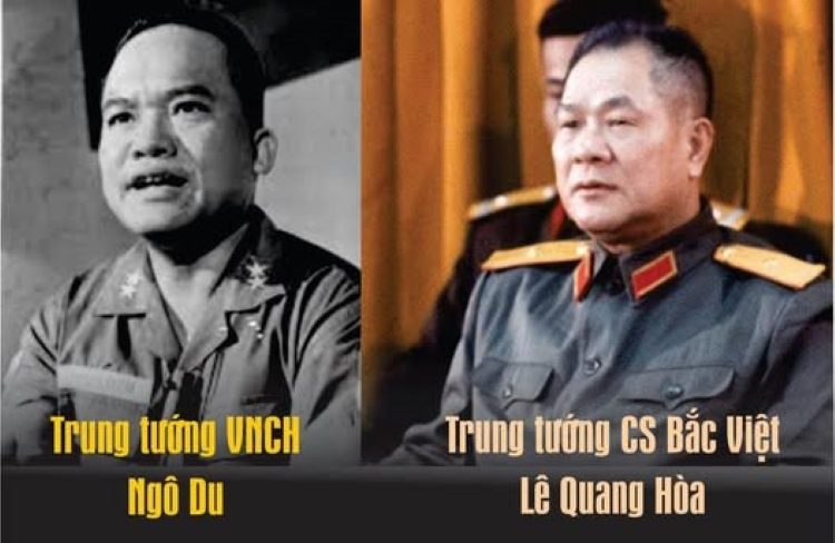
Đây là một phần tư liệu bị khuất, sau 1975 góp phần làm rõ bộ mặt của Hà Nội, được chính Sĩ quan bảo vệ an ninh tướng CSVN Lê Quang Hòa, và các cựu cán bộ của đảng CSVN kể lại. Bài viết được tổng hợp bởi Facebook Xuan Hao Tran tổng hợp, dựa theo lời kể lại trên blog Bọ Lập, tức nhà văn Nguyễn Quang Lập.
Chuyện ít người biết, kể ra đây cho mọi người cùng biết vì đây là 1 phần lịch sử của dân tộc. Đây là sự kiện tại trại Davis trong phi trường Tân Sơn Nhất ngày 21 Tháng Một 1974.
Ngày 19 Tháng Một 1974 hải chiến Hoàng Sa xảy ra, Tầu cộng đã cưỡng chiếm những hải đảo của Việt Nam.
Nghị trình của phía Công sản Bắc Việt đưa vào cuộc họp lần này vẫn là những luận điệu vu cáo và lên án Việt Nam Cộng Hòa (VNCH) vi phạm hiệp định Paris bằng miệng như thường lệ.
Họ cứ lải nhải tố cáo VNCH vi phạm tại Quảng Ngãi, Nam An Lộc…v.v.. Phái đoàn cs không đả động gì tới sự kiện Hoàng Sa vừa diễn ra hai hôm trước.
Phái đoàn Việt Nam Cộng Hoà đưa vấn đề Hoàng Sa vào nghị trình. Vấn đề Hoàng Sa được viết bằng văn bản gồm có hai phần:
1) Đề nghị chính thức Việt Nam Dân Chủ Cộng Hòa cùng với Việt Nam Cộng Hoà ra thông cáo lên án hành động xâm lược lãnh thổ – lãnh hải của Việt Nam.
2) Yêu cầu phía quân đội Việt Nam Dân Chủ Cộng Hòa cùng Mặt Trận Giải Phóng Miền Nam (MTGPMN) không tấn công phá rối các phi trường, quân cảng Đà Nẵng, Nha Trang thuộc Quân Đoàn I, II để VNCH phối trí tập trung lực lượng tái chiếm Hoàng Sa.
Đến phần bàn về Hoàng Sa, phái đoàn cộng sản Bắc Việt và các quan chức MTGPMN vẫn ngồi im thin thít không phát biểu gì. Mọi con mắt của đại diện quốc tế đều đổ dồn về phía họ. Phái đoàn cộng sản bí quá đành giở trò câu giờ… cho hết buổi họp.
Phái đoàn VNCH yêu cầu tiếp tục họp bất thường. Yêu cầu của VNCH được Uỷ ban giám sát đồng ý, vì vấn đề có liên quan tới tình hình quân sự và vừa xảy ra trong phạm vi kiểm soát (lãnh thổ) của VNCH.
Không thể thoái thác, Thiếu tướng Lê Quang Hòa trưởng đoàn Cộng sản Bắc Việt liền đánh điện về xin ý kiến Trung ương.
Lê Đức Thọ trưởng ban Miền Nam, Uỷ viên thường trực bộ chính trị đã trả lời “lập trường chính trị của các anh để đâu? Đang có chiến tranh, lại phối hợp hoạt động với địch à? Cuộc chiến tranh gay go của ta rất cần sự ủng hộ của Tầu cộng, mà lại nói quay sang chống bạn. Họ có giải phóng giúp ta, thì sau này cũng trả lại cho ta thôi.’’
Trong phiên họp bất thường, Trung Tướng Ngô Du trưởng phái đoàn VNCH, người chủ trì cuộc họp đưa ra đề nghị:
“Trong phiên họp này, tôi đề nghị không cáo buộc, cãi nhau về những vụ xâm phạm lãnh thổ, vi phạm hiệp định Paris nữa. Tầu cộng đã ngang nhiên xâm lược và chiếm giữ toàn bộ quần đảo Hoàng Sa. Đất của chúng tôi thì cũng như đất của các anh vì cùng là đất tổ tiên chúng ta để lại cả. Vì thế, chúng ta nên xếp ba bốn cái vụ tranh cãi lại, để ngồi cùng nhau bàn bạc về việc phối hợp hoạt động chống lại sự xâm lăng này. Yêu cầu VNDCCH cùng VNCH gửi công hàm lên án Tầu cộng tại Liên Hiệp Quốc, VNDCCH nên vận động phe XHCN và cũng như thế giới lên tiếng phản đối (Tầu cộng)”
Mọi con mắt của các đại diện quốc tế trong uỷ ban đổ dồn về phía phái đoàn cộng sản. Họ lại tảng lờ…
Một lúc, tướng Ngô Du nổi nóng. Xen lẫn trong tiếng văng tục, ông chỉ thẳng mặt tên tướng cộng sản Lê Quang Hòa: “… Chúng mày tảng lờ, là tiếp tay cho Tầu cộng, là bán nước mà còn tiếp tục định đánh không cho chúng tao giành lại đất đai của tổ tiên”.
Tướng Ngô Du chụp lấy cái gạt tàn thuốc lá bằng thủy tinh ném thẳng vào mặt Lê Quang Hòa. Hắn né được, cái gạt tàn đập vào tường vỡ nát.
Cận vệ của Lê Quang Hòa lao tới tướng Ngô Du thì liền bị cận vệ của tướng Ngô Du ngăn cản và bẻ (khóa) tay.
https://saigonnhonews.com/thoi-su/thay-gi-tren-mang/dieu-chua-ke-sau-cuoc-hai-chien-hoang-sa-1974/
20260608 Why did China attack South Vietnam? Paracel Islands
https://www.youtube.com/watch?v=KhwWs3N6J3Y
Pinned by @Kabutoes
@Kabutoes
3 years ago
The New York Times: PEKING REPORTS HOLDING U.S. AIDE - The New York Times (nytimes.com)
WASHINGTON, Jan. 25 China has informed the United States that she is holding an American Embassy observer who was reported missing last weekend during a battle between Chinese and South Vietnamese forces in the Paracel Islands, the State Department said today.
John F. King, department spokesman, said the Chinese authorities had told Washington that Gerald Emil Kosh, 27‐year‐old civilian employe of the Defense Department attached to the Embassy in Saigon, was taken into custody with more than 100 South Vietnamese captured on Pattie Island, one of the Paracels.
“We regret that this had to happen and that he was on the disputed territory,” Mr. King said. “We think he ought to be released soon.” He said he did not know where Mr. Kosh was being held or what his condition was.
Privately some officials said they expected that both Mr. Kosh, a former Army captain, and the South Vietnamese would be set free by the Chinese, but because of the sensitivity of the subject, Mr. King was not permitted to go further than his statement.
He confirmed that the information had been conveyed to the State Department by the Chinese liaison office here.
Mr. Kosh was on a South Vietnamese naval patrol off the Paracels when fighting broke out between South Vietnamese and Chinese forces. The Vietnamese commander put Mr. Kosh ashore on Pattie, where he was apparently taken into custody by Chinese occupying the island.
Dig deeper into the moment.
The battle flared last weekend on the Paracels, an archipelago 200 miles east of Da Nang and about 150 miles south of the Chinese island of Hainan.
China and South Vietnam have claimed sovereignty over the islands, and there has been speculation here that the Chinese were interested in them because of reports of oil deposits nearby.
The United States has avoided taking sides in the dispute, with Secretary of State Kissinger limiting his comments to regret that force had been invoked.
Discussions with the Chinese began here early in the week, soon after Mr. Kissinger returned from his Middle East trip. ‐The United States asked for information on Mr. Kosh's whereabouts and for cooperation in releasing him and the South Vietnamese.
Because discussions with China are treated with more sensitivity than those with most other countries, the department refused to announce the approach until today, after The New York Times quoted Administration officials to the effect that‐inquiries had been made, and after information had been received that Mr. Kosh was alive.
The American, who is from Lafayette Hill, Pa., served in the Army in Vietnam and was assigned to the Defense Attaché's Office to observe South Vietnamese units in action.
The United States, which has sought to avoid creating a major issue, showed no enthusiasm for Saigon's efforts to bring the matter before the United Nations Security Council, a move now apparently dropped.
“Hoa Kỳ – vốn tìm cách tránh gây ra vấn đề lớn – đã không tỏ ra mặn mà với những nỗ lực của Sài Gòn nhằm đưa vụ việc ra trước Hội đồng Bảo an Liên Hợp Quốc; một động thái mà nay dường như đã bị từ bỏ.”
Some officials noted that North Vietnam had said nothing about the dispute, indicating that it was in the difficult position of not wanting to endorse Chinese seizure of an island traditionally claimed by the Vietnamese but of being unable to criticize China.
“Một số quan chức lưu ý rằng Bắc Việt Nam không hề lên tiếng về vụ tranh chấp, cho thấy họ đang ở vào thế khó: vừa không muốn tán thành việc Trung Quốc chiếm giữ hòn đảo vốn được phía Việt Nam tuyên bố chủ quyền từ lâu, lại vừa không thể công khai chỉ trích Trung Quốc.”
Matter Termed Closed at U.N.
Special to The New York Vines
Why did China attack South Vietnam? Paracel Islands
No comments:
Post a Comment